


Devon and Cornwall have been under a hosepipe ban since 8 August. By late October Wimbleball, on Exmoor, was down to 12.5%, and the Environment Agency had granted South West Water a drought permit to keep it going.
Then Storm Austen came in off the Atlantic. Over the following fortnight it did something revealing: it refilled some reservoirs and barely touched others.
Venford, a small Edwardian reservoir high on Dartmoor, went from 20% to 53%. That undid 84 days of drawdown, taking it back to where it stood on 28 July. Burrator, the Victorian reservoir above Plymouth, went back to 10 August. Roadford, Devon's largest reservoir by far, on farmland west of the moor, rose by less than two points. The storm rewound it by five days.
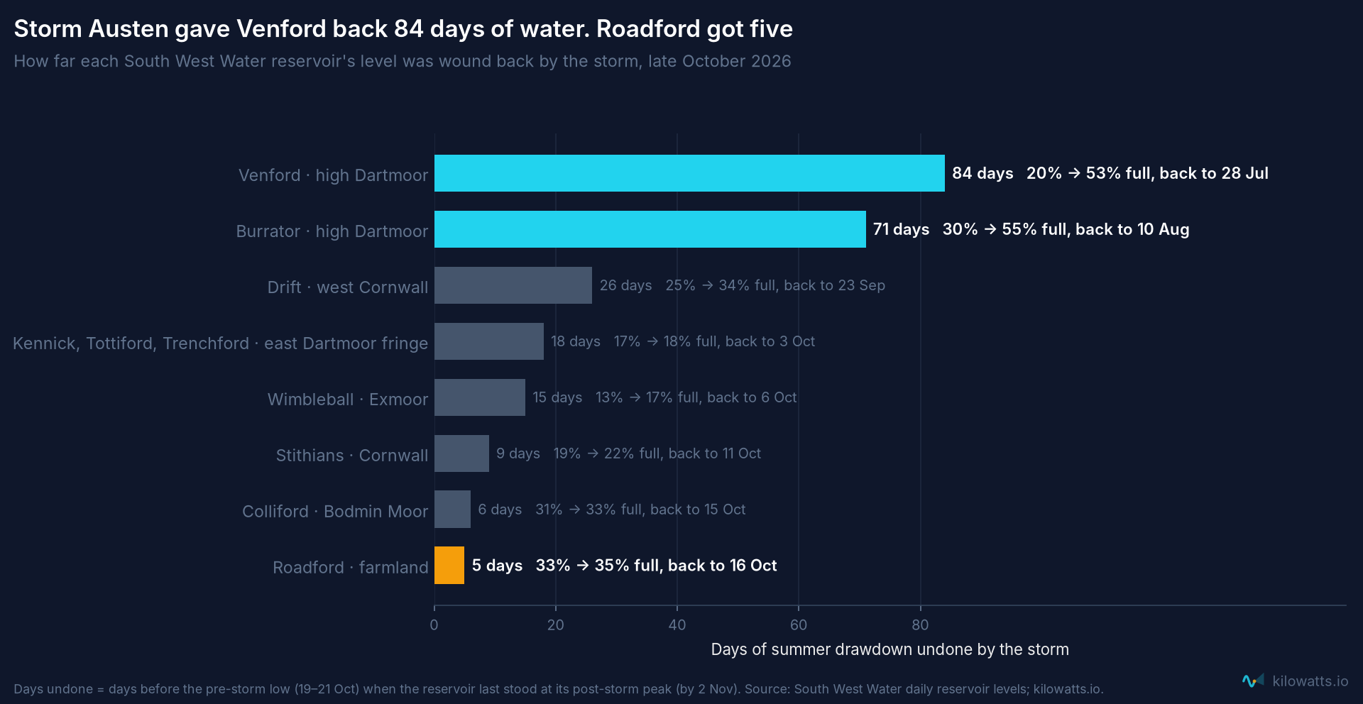
That gap is not bad luck. It is geography, and it was chosen. In 1970 Parliament stopped a reservoir at Swincombe, in the wettest valley on Dartmoor, three and a half miles from Venford. Devon got Roadford instead. This piece asks what that decision has cost.
The moor is where the water is
A reservoir fills from its catchment, the land that drains into it. I mapped every South West Water catchment from a 30-metre terrain model, then overlaid the Met Office's 1 km rainfall grid for 1991–2020.
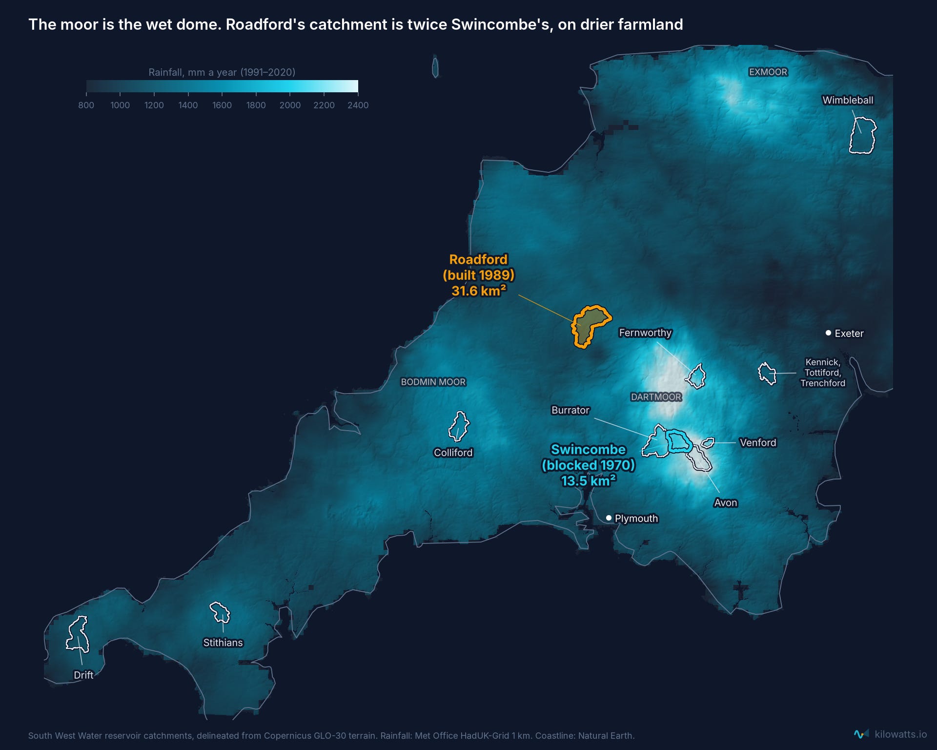
The unbuilt Swincombe catchment gets 2,180 mm of rain a year, at an average height of 400 m. Roadford's gets 1,257 mm, at 183 m. Fernworthy (2,080 mm) and Venford (2,160 mm) are just as wet as Swincombe. They aren't worse sites, only smaller dams.
Rain is only half of it. What matters in a drought is what still runs off the land in August. The East Dart at Bellever, the gauged river closest to Swincombe, yields 1,900 mm of runoff a year from each square kilometre. The Wolf, which feeds Roadford, yields about 780 mm. In dry summers the gap widens: from April to September 2022 the East Dart gave 294 mm, against 51 mm from the Wolf. Peat over granite keeps the moor's rivers running when the clay farmland has dried out.
Two dams, one drought
To see what that means for supply, I replayed both sites through every drought since 1975, using measured daily river flows. Each gets the same 34,500 ML of storage as Roadford, the same modern demand and the same drought rules South West Water appears to follow. For the last few summers I can do better than a fixed demand. South West Water publishes Roadford's levels, so I worked out how much it actually took out each day (the river inflow minus the change in storage, which rebuilds the published levels to within a point) and gave Swincombe exactly the same withdrawals.
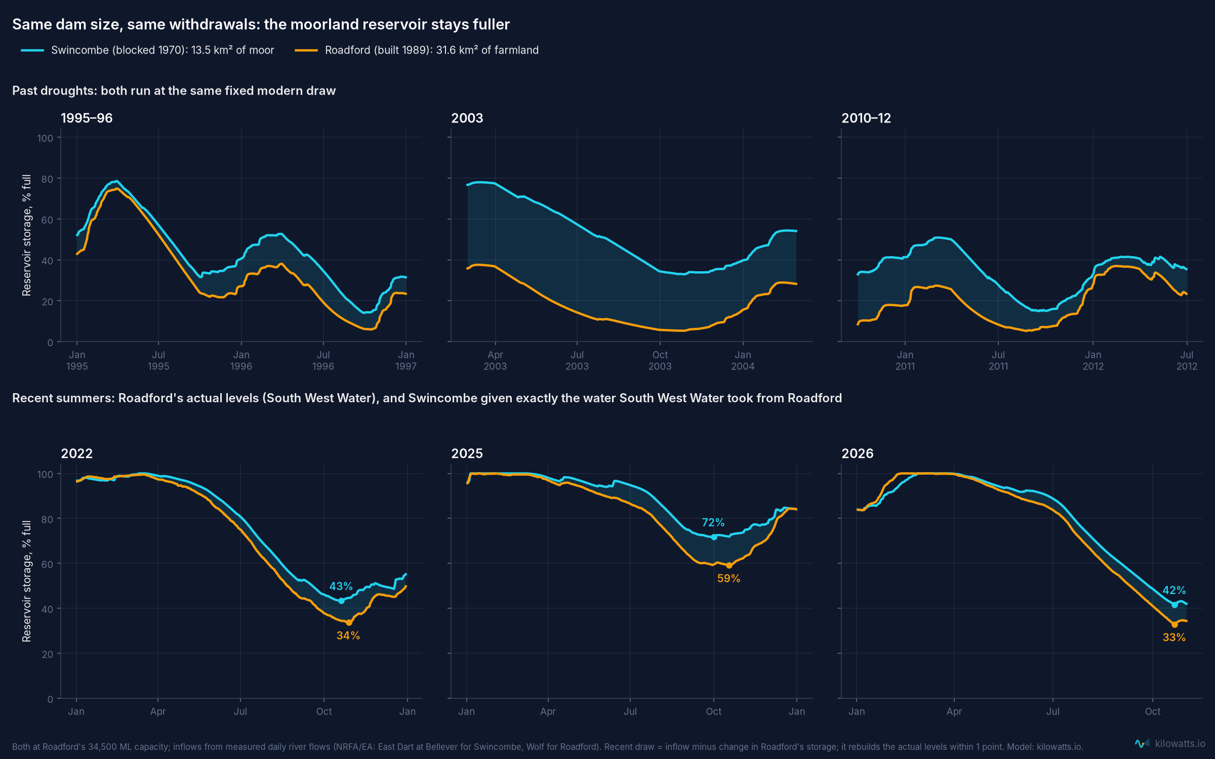
From a catchment less than half the size (13.5 km² against 31.6 km²), Swincombe comes out ahead:
Its drought yield, the largest steady draw it could sustain without running dry, is 68 ML a day, against Roadford's 60.
From 1975 to 2026 it would have fallen short by 70 billion litres. Roadford falls short by 174 billion, two and a half times as much.
In 2003 Swincombe tops up every autumn and never runs short. Roadford misses a third of demand.
On South West Water's actual withdrawals, Roadford bottomed out at 34% in 2022, 59% in 2025 and 33% this October. Swincombe would have stood at 43%, 72% and 42%: about a tenth of the reservoir fuller at the end of every recent summer.
In 1976, the worst drought on record, both run nearly dry. No site in Devon would have coped with 1976 unaided.
The replay is a stress test, not a forecast. It runs each reservoir on its own, while the real Roadford zone also draws on rivers, Burrator and pumped storage. The comparison between the two sites is the point, not the absolute shortfalls.
The Victorians knew this. Per 1,000 ML of storage, Burrator (1898) and Venford (1907) deliver about four times the drought yield of Roadford (1989), because they refill several times a year. That isn't better engineering. They are simply in the right place.
Water has been fought over on Dartmoor before
Swincombe's water was spoken for long before 1970. In the early 1890s the London County Council's chief engineer, Alexander Binnie, suggested Dartmoor as a gravity source for the capital. Nothing came of it.
In 1920 a private company promoted the Dartmoor and District Hydro-Electric Supply Bill: eight reservoirs, several weirs and five power stations, to power a copper refinery near Newton Abbot. Its schedule included "the Foxtor Mires Reservoir", with an embankment across the River Swincombe: the same valley, fifty years early. The water clauses were dropped, The Times reported, "in deference to the opposition from the Duchy of Cornwall and the Devon County Council". The Dartmoor Preservation Association opposed it too. Robert Burnard, one of its leading figures since the 1890s, wrote against "disfiguring electric-power stations" and had urged Devon County Council to buy the moor as a county park.
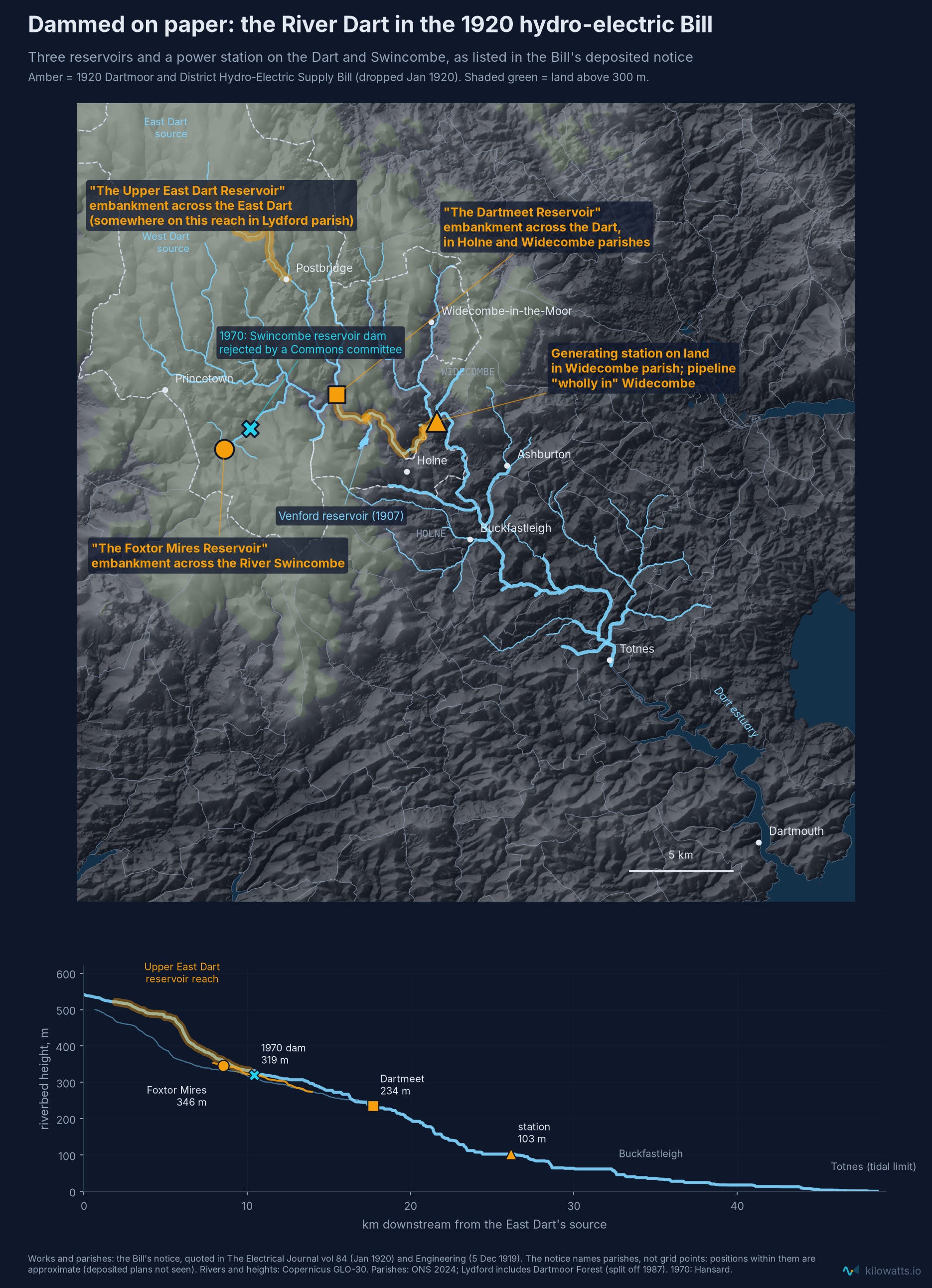
The scheme was not as mad as it might sound. In 1920 most of Devon had no electricity at all, coal was expensive after the war, and falling water was the obvious way to make power without it. A smaller version did get built: the Mary Tavy and Morwellham stations on the moor's western edge opened in the 1930s and still run. But the Bill gives no output figure, and when I estimate one from the terrain and measured river flows, the Dart arm comes to something like 60 GWh a year. That is roughly what five or six modern onshore wind turbines make, from three dams and a flooded Dartmeet. When I've looked at the options for hydro on Dartmoor myself, I came to a similar conclusion: the moor is high and wet, but its rivers are too small for substantial generation. Its water is worth more as drinking water than as electricity.
The moor's wind is a different story. On the Global Wind Atlas, Dartmoor averages 8.9 metres a second at turbine height, windier than 91% of England's land, and Princetown gets nearly 10. As I told a meeting there last month, a single large modern turbine near the village could sell its power for around 10p a unit, well under half what households there pay.
The usual objection is that turbines would spoil a wild place. But the open moor is not wild. Pollen preserved in its peat shows that farmers cleared most of its woodland from about 4000 BC, and by the start of the Bronze Age, around 4,000 years ago, the high moor was largely open ground. The stone field boundaries that still cross it, the reaves, were laid out about 3,600 years ago (Dartmoor National Park Authority). Dartmoor's bare hills are a farmed landscape, kept bare by grazing ever since.
Fifty years later Burnard's granddaughter, Lady Sylvia Sayer, chaired the Association when it opposed the Swincombe reservoir.
Piping water a long way is not as mad as it sounds. Manchester has drunk from Thirlmere in the Lake District since 1894, through a 96-mile aqueduct. Liverpool's water comes 68 miles from Lake Vyrnwy, and Birmingham's 73 miles from the Elan Valley. London's only problem was that the nearest wet hills were further away: Dartmoor is about 180 miles in a straight line.
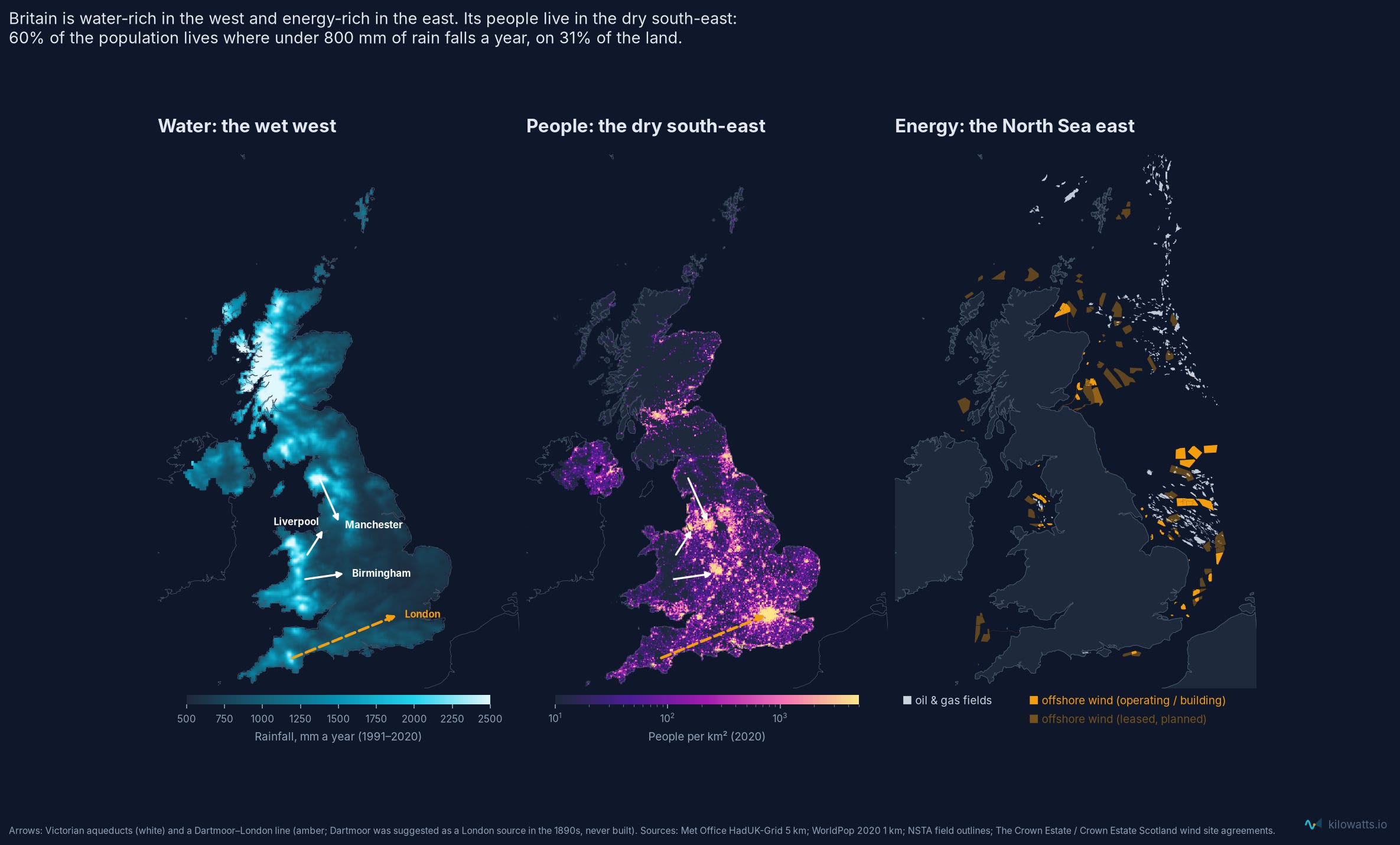
That is the shape of the country. Sixty per cent of the UK's population lives where less than 800 mm of rain falls a year, on 31% of the land. Only 2% of people live where more than 1,500 mm falls, although that wet land is a fifth of the country. The energy map is a mirror image: oil, gas and most of the wind sit in the shallow North Sea to the east. West of Britain the sea is deep enough to need floating turbines, and on land the windiest hills are the most protected. Water and wind in the west hit the same wall.
How Swincombe was stopped
In 1968 the Water Resources Board studied 80 schemes at more than 30 sites for the south west, and recommended a reservoir on the Swincombe. Plymouth Corporation and the South West Devon Water Board promoted the Plymouth and South West Devon Water Bill to build it: a 135-foot dam flooding 745 acres of Fox Tor Mires, to supply about half a million people (Hansard, 14 April 1970).
The promoters set out the alternatives in farms. Lee Mill would have destroyed 8 farms, Townleigh 7, Lamelgate 7, Woodcourt 6, Curtis 3. Swincombe would have destroyed none, and affected two. The Commons gave the Bill a second reading by 120 votes to 23. Its petitioners included the Duchy of Cornwall as landowner, Devon County Council, the Dart fisheries and amenity societies. On 3 December 1970 the committee of four MPs found that the promoters had not proved their case, and gave no reasons. The farm and landowner lobbies kept pressing for Swincombe through the 1970s, but in July 1975 the new South West Water Authority dropped it and chose Roadford.
Speaking in the Commons in 1980, Tony Speller, the MP for North Devon, said the authorities had come to treat moorland as off-limits. Roadford, he said, was selected "out of 39 sites", on good agricultural land (Hansard, 12 March 1980). The National Farmers' Union backed Swincombe. In 1985 the Dartmoor Preservation Association bought land in the Swincombe valley with a bequest.
The pattern recurs. When Meldon reservoir was proposed in the 1960s, Parliament's joint committee on the scheme ordered "a fair comparison between the Meldon and Gorhuish schemes", Gorhuish being a lowland farmland alternative (Hansard, 24 October 1968). The river there yields 758 mm a year against Meldon's 1,780, and a tenth as much in a dry summer. Meldon was built in 1972 anyway. In the Okehampton bypass inquiry, the alternative to a route through the edge of the National Park was a northern route across farmland. The inspector judged that route more environmentally damaging, and Parliament passed a special Act to build the southern one.
The same thing happened with Plymouth's airport, and the pattern matters more here than the aircraft. In 1961 the city promoted a Bill to turn RAF Harrowbeer, a wartime airfield on Roborough Down inside the National Park, into its airport. The opponents, Devon County Council and eight amenity bodies, argued that common land in a National Park should not be taken by a private Bill (Hansard, 14 February 1961). A Lords Select Committee rejected it (Hansard, 8 February 1962). Plymouth stayed at Roborough, which the promoters had called the more expensive site with the shorter runway. Its runway never grew past 1,160 metres, and the airport closed in 2011. You don't have to want more flights to see the shape of it: the moorland option was ruled out on principle, and the cost was a less capable site that the area kept for fifty years.
Each decision to keep infrastructure off the moor was Parliament's, made in the spirit of its time. The costs landed elsewhere: on farmland, on drought resilience, and on a city left with the weaker site.
What it costs
In a normal year the difference barely shows in bills. South West Water's water-only bill is about £315, against an industry average of £309; its notorious bills are mostly sewerage. Nor do bills say anything about when water is scarce. A litre costs the same in a dry August as in a wet January, which is the problem I wrote about when South West Water fitted my smart meter (Paying for August All Year Round). The cost of building in the wrong place shows up in droughts, so the right way to price it is like a power cut: what is the supply worth when it isn't there?
There are two ways to answer:
Insurance. Swincombe's extra 8 ML a day of drought yield would cost about £10m a year to replace at South West Water's own price for desalination, roughly £25 a year per household in the Roadford supply zone. The range runs from about £1.5m to £24m, depending on the source.
Lost load. One day of rota cuts or standpipes across the Roadford zone would cost households about £32m, using Water UK's valuation, and businesses about £26m in lost output: roughly £57m in all.
Put those together and Swincombe would pay for itself if it averted one day of standpipes every six years. In the stress-test replay, Roadford reaches that territory in seven of the last 51 years; a same-size Swincombe, in three.
The strongest counter-argument comes from South West Water itself. Its water resources plan says Roadford's output is limited by its pipes and treatment works, not by raw water. That may be true on paper, but in 2023 Cornwall's hosepipe ban ended first because Colliford had recovered. Most of Devon stayed under the ban because Roadford had not.
Food versus water
Roadford was designed for the climate of the 1970s. The Environment Agency now projects that, unless more is built, England's public water supply will be around 5 billion litres a day short by 2055 (Environment Agency, 2025). The Met Office's projections for the 2070s, under high emissions, range from summers 47% drier to 2% wetter, and winters up to 35% wetter (Met Office, UKCP18). Nobody knows where in that range Devon will land, but the cost of getting it wrong is not abstract. A day of standpipes across the Roadford zone costs around £57m, it falls in the tourist season when demand peaks, and drought permits take the shortfall out of rivers that hold salmon.
The rain will also come differently. The Met Office expects more winter rain to arrive in intense frontal storms and more summer rain in short, heavy showers, with the hourly downpour you'd expect once every two years about a quarter heavier by 2070. That is a climate of long dry spells broken by storms like Austen, and a reservoir only helps if it can catch the storm when it comes. That takes two things in the same place: rain and room to store it. Venford had the rain but is tiny. Roadford had the room, nearly two-thirds empty, but not the rain. Burrator, an eighth of Roadford's size, took in 1,044 million litres from the storm; Roadford took in 622 million. A reservoir at Swincombe, sized like Roadford, would have had both.
England's answer is nine new reservoirs by 2050, and most of them are going on farmland. The largest, near Abingdon in Oxfordshire, would cover 670 hectares. The Fens Reservoir, north of Chatteris, sits in a district of grade 1 and 2 land, the best arable land in the country. Two more are planned in Somerset. That sits awkwardly with the government's own Land Use Framework, published this year. It promises to "maintain overall food production in England" and to "safeguard our best and most versatile farmland from permanent land use change", steering other uses "towards less productive land". The same document calls moorlands and peatlands the "natural water towers" of England (Land Use Framework, 2026). It says that about restoring peat, not building dams. But read together, its own principles point one way: grow food on the best land, and collect water from the hills. Reservoir planning is still doing the opposite.
Dartmoor shows what that choice looks like. Swincombe would have flooded 301 hectares of moorland mire and destroyed no farms. Roadford flooded 295 hectares of farmland in its place, and the lowland alternatives Parliament was shown in 1970 would each have destroyed between three and eight farms. The land take was the same. The difference was that one site was a mire and the other was farms, and that the farms catch far less rain. A lowland reservoir has to be bigger to give the same protection in a drought.
In 1970 Parliament, the Duchy of Cornwall, Devon County Council and the amenity societies made a choice that was reasonable for its time. Fifty years on, we are still planning water by its logic. Many of the people making today's decisions were alive in 1970. The people who will live with the droughts of the 2070s are at school now, and they may ask a harder question than the one asked then. Not "is Fox Tor Mire beautiful?", which it is, but "why did we flood the farms and keep the wettest valley in Devon empty?" So what would planning for the 2070s, rather than the 1970s, look like? It would start with different questions:
If summers get much drier, should Devon still rely on a reservoir in the part of the county that dries out first?
Should we keep flooding good farmland while the wettest valleys stay empty, in a country that has promised to protect its best land for food?
Should the plan for Dartmoor count water as one of the moor's products, alongside its peat, its wildlife and its visitors?
Could peat restoration and a reservoir be planned together, since wetter peat means steadier rivers to fill it?
And when the children of the 2070s look back at what we decided in the 2020s, what do we want them to see?
If the uplands stay off-limits, every future drought will be answered by drowning more farmland in the valleys below them.
The plan for the moor's next five years
Dartmoor National Park Authority is consulting until 22 November on its draft Partnership Plan for 2027–2032, the shared five-year plan for the park (draft plan and questionnaire).
Its 21 pages never use the words reservoir, water supply, abstraction, hydro, wind, solar or renewable. Drought appears once, as a risk to farm businesses. Energy appears only as home energy efficiency.
Water appears only as ecology, and here the plan is good. It sets targets for 1,500 more hectares of peat restoration and for more rivers in good ecological health. Restored peat holds water and releases it slowly, which raises summer low flows: exactly what a moorland reservoir needs. The plan doesn't count that as a benefit to the people downstream who drink Dartmoor water, though it could.
The plan is also modest about the people who live in the park. By the government's own statistics, Dartmoor's residents are poorer than those of most English national parks and, allowing for age, in worse health than any of them. Its over-65 share is also rising more than twice as fast as England's.
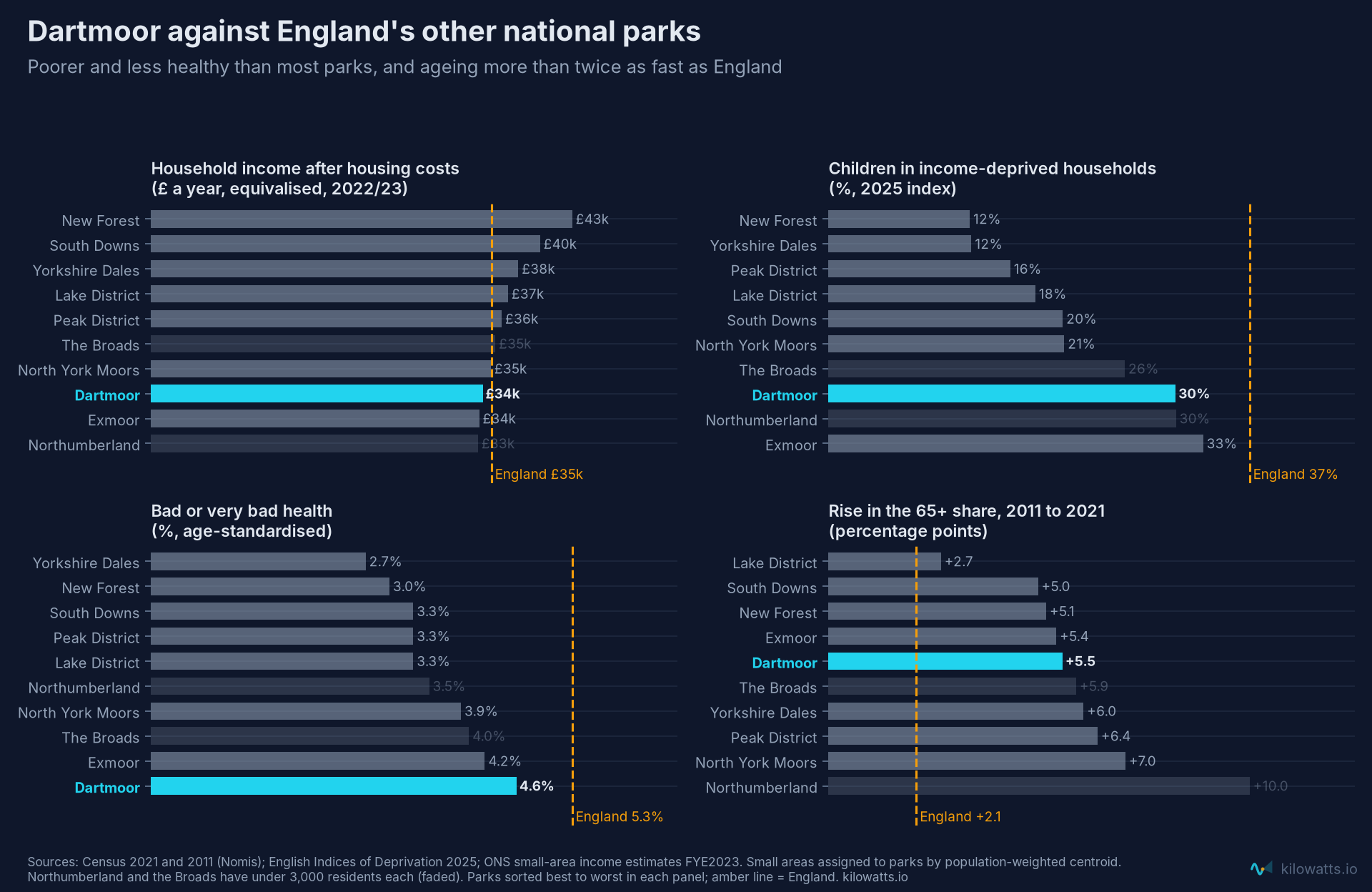
Against that, the plan targets at least 30 affordable homes a year, about 0.2% of the park's 14,900 households. A quarter of those households heat with oil or bottled gas alone, six times the English rate, yet the plan's only retrofit target is to "increase community engagement" with energy efficiency, with no number attached.
The moor's most valuable product, in a dry year, is the water that runs off it. A plan for the park's economy should say so. If you agree, the questionnaire is open until 22 November.
Data and methods: South West Water reservoir levels (digitised from its weekly charts); catchments delineated from Copernicus GLO-30; Met Office HadUK-Grid v1.3.1 rainfall; NRFA and Environment Agency river flows; WorldPop 2020; NSTA and Crown Estate offshore data; Water UK (2016) and SWW WRMP24 cost inputs; Census 2011 and 2021 (Nomis), English Indices of Deprivation 2025 and ONS small-area income estimates (2022/23). Code and data on request.